Kuhflucht Falls, Upper Bavaria

Not far from Garmisch-Partenkirchen, a great motive and an adventure trail presents a unique experience and many opportunities for photographers. The Kuhflucht Falls are not as famous as the world-known Partnach Gorge, but they are worth the trip.
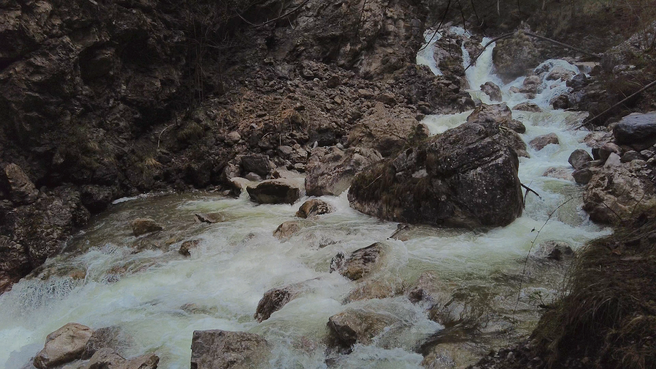
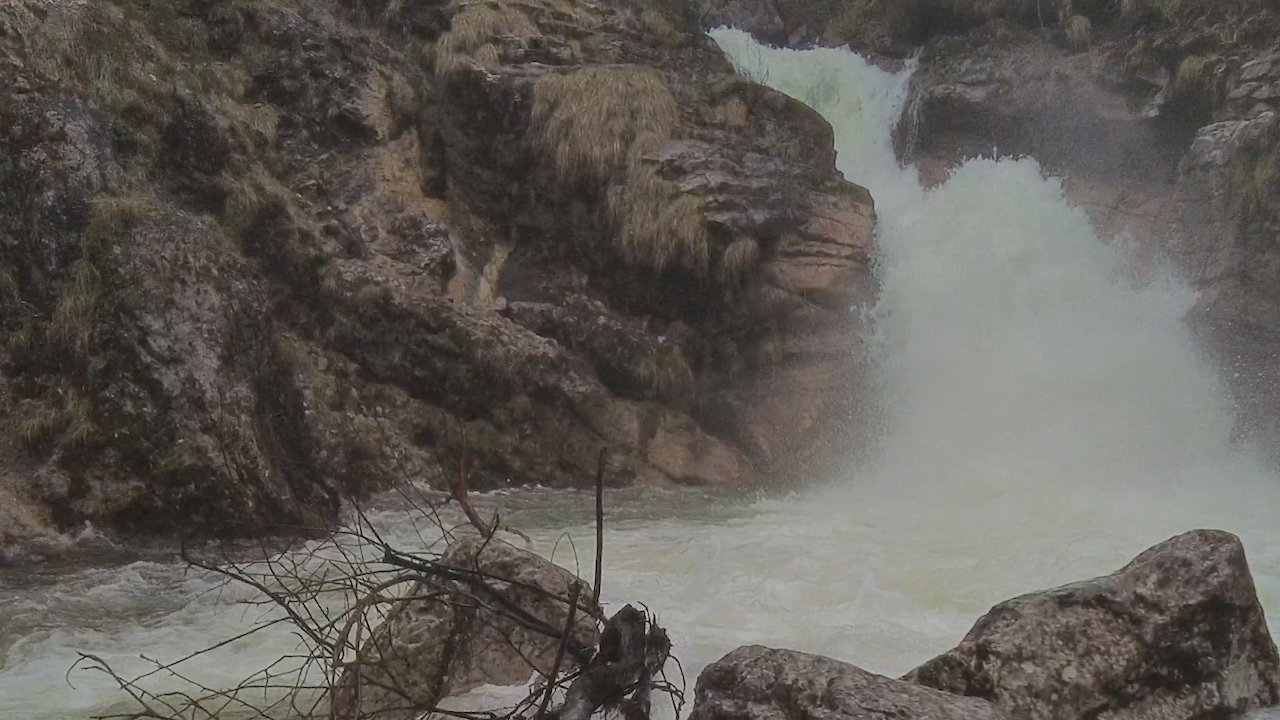
It’s good to know some things in advance to plan a trip there. The Kuhflucht Waterfalls have a height of 270 meters, but please do not expect one big waterfall. The stream cascades over some steps and contains three big falls. One particularly impressive cascade is near the bridge over the stream.
The falls are in some places inside a canyon. You can’t see the whole falls (except using a drone, which would require a permit), but there are many impressive motives along the way.
There are two parking lots in Farchant. One lot is where the trailhead of the hiking trail to the waterfall begins. The trail is connected to an adventure and experience trail leading through a forest with a lot of information about nature and a playground.


The lower part of the trail and the other trail offer a lot for families, and many people come here.
If you look for dramatic pictures, the season and the time of the day are important: These pictures were taken during spring after days of rain, and the snow melts. That makes a difference because much more water is cascading down over the boulders. It’s a different picture in a dry summer.
Late morning seems a good time since there is enough sunlight entering the canyon. High mountains and a dense forest with large trees surround the falls.


The trail is very comfortable in the lower part. The community of Farchant put a tremendous effort into this trail and some attractions there. After a severe storm with massive damages, the trail was repaired and reopened. Thanks to this effort, visitors can enjoy these romantic falls throughout the year. After approximately 750 metres the trail reaches a bridge over the stream.
Before the bridge, a smaller trail departs, where you can hike up a few meters to a viewpoint that offers an impressive view over the fall. After the bridge, the broad trail turns into a steep mountain path.
That path that leads higher up the mountain has a different quality. You should only do this hike if you are an experienced hiker. There is one scenic view, approximately 20 minutes from the bridge, where you can see the upper part of the gorge, but please be careful there!

You can also hike back on the “Philosophenweg” to Garmisch-Partenkirchen.
The Kuhflucht Falls are accessible via Train-Stop Farchant and by bus from Garmisch Partenkirchen.

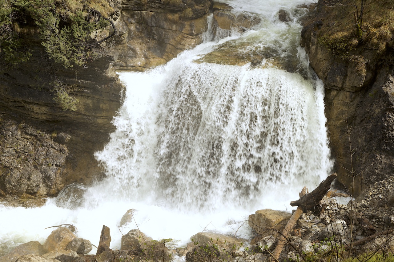
The biggest fall is impressive after days of rain in spring or when the snow melts.

Standing close to the big cascades is a good feeling, it is not only the experience of majestic nature but the little water particles in the air open the airways and have a comforting effect. The effect is similar to standing at the shore of the sea and breathing the air close to the waves.

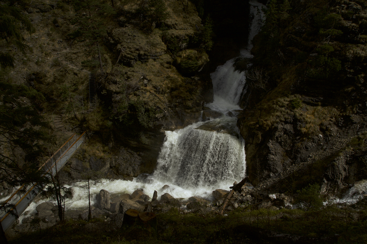
Above the bridge is a scenic view which allows a breath-taking perspective

The Kuhflucht Falls is an alternative or additional trip to the well-known destinations in the region.

MAGIC ATMOSPHERE ABOVE THE CLOUDS: HIGH-FOG IN THE ALPS

Ideas for landscape photography in the colder season

Autumn is just around the corner. This means the days are getting shorter. The colours change. In some regions like the Alps there is more often high fog, a weather pattern where hills and peaks sometimes are above the clouds.

Fog is interesting for photographers in many ways. It adds mood and atmosphere to the pictures. Fog is useful in landscape pictures to add structure. Of course if the fog is very strong and there is nothing but a white wall it is an obstacle.

Misty days occur mostly in autumn, spring and winter. The change of temperature and moisture creates fog. There are a lot of interesting phenomena connected with fog. Sometimes it is a thin veil above a meadow. On other occasions there are thick layers of fog and the fog lasts the whole days. Sometime the fog is moving, sometimes not. In time-lapse videos the movement of fog is somehow similar to water. The shrouds of mists “float” along mountain peaks.

Since misty air is colder the fog can “fall” like a water-fall for example when fog floats over a ridge into a valley. Fog begins to form often before sunset and lasts in the morning hours. When the sun shines the mist often disappears during the day. However in river valleys like the Danube valley the mist can last much longer. It is often significantly colder in these day.

Fog is more often in regions with wetter soil like bog or wet meadows. It happens in summer too. Shrouds of mist appear after hail showers or after thunderstorms too. In July the first mornings with fog are early harbingers of the changing season. As the days become shorter and the nights getting colder misty mornings happen more often.

Its often hard to say if the fog lifts or disappears during the day. There are many different weather conditions. Fog can be also dangerous when it suddenly forms and the visibility turns to near zero. Drivers are surprised and can’t see a thing. Since conditions on a foggy day can always change quickly it is good for drivers to slow down particularly on motorways and highways when a layer of fog appears.

If the weather is cold fog can lead to hoar frost. Ice crystals form and surround twigs and trees. This a particularly interesting phenomenon.

There is one form of fog which is great for photographers if they are in a regions with hills or mountains. Mostly in autumn there are days with high fog. This happens when a thermal inversion occurs. This means you have low ground temperatures and a layer of higher temperatures above that prevent the convection currents. These convection currents usually mix in the atmosphere. You can think of a thermal inversion like a saucepan lid. It keeps the colder moist air layer with fog from rising. This happens a lot in basins and during periods of high pressure weather when there is not much wind.

The video below was taken in the morning of February 28, 2021 with a Canon 5d Mark2. The time-lapse shows the movement of the shrouds of mist above the hillside between the Hohen Peissenberg and the peaks of the Bavarian mountains. There is a quick change in visibility and a change in lighting condition. For video it is good to go into manual mode and fix aperture before shooting.

At the border between the layer of cold air and the warm air on top the cold air layer there are very interesting effects which are useful for pictures and videos. The challenge is to predict where that border is: Where does the blue sky break through the thick layer of mist? And when does it happen? Actually this is a lot of try and error.

Knowing some good places is “money in the bank”. You might want to get to a hill or mountain which is easily accessible and high enough that you can get above the cold air layer with mist. In Germany, Bavaria the Hohen Peissenberg with its famous old weather observatory is a good spot. Mostly because there is a road to the top of this mountain. The top of the Hohen Peissenberg has an elevation of 987 metres. However on some days the layer of mist will be above your heads and you need to find a higher mountain.

The pictures were taken on a spring day in 2021. That day there was a typical thermal inversion. In the morning the Hohen Peissenberg mountain was in the middle of a thick layer of high fog. But in the following hours the sun broke through and there was a very interesting scenery with fast changing moods and impressions.

The Forest between mist and light

Hoar Frost after a cold night in the mist. When the mist disappears the whitened trees create a unique scenery
Looking towards the Allgäu Mountains

The wilderness near the top of the Hohenpeissenberg Mountain. The fog creates an otherworldly atmosphere.

Sunset And Foehn Effect


October 31, 2018 was a day with an unforgettable sunset in many places. On the eve of the Halloween night the sky was burning. Bright yellow and red colored clouds illuminated the sky. The extraordinary evening glow is a typical phenomenon in autumn.

In Upper Bavaria the foehn effect delivered the perfect conditions for the fire in the sky. The Northern side of the alps was very lucky since there were normal weather conditions during that evening in a year full of extremes. These extremes still continue. The foehn effect was generated by the torrential rainfall on the Southern side of the mountains. Subsequently, wet air was rising on one side and descending on the other side.

Shortly before sunset: The Sun illuminates the cloud layer


Before that Halloween evening there were also severe weather on the Northern side of the alps in Bavaria. There was an extreme windstorm which inter-cut railway connections in Upper Bavaria. Foehn windstorms can be dangerous particular on the mountain tops and some valleys.

Typical Foehn sky: a very clear view of the mountains


During the day the weather had calmed down and there were these impressing cloud patterns in the sky. The good thing was that the clouds got stopped and had not moved too much to the south. Therefore the sun appeared shortly before sunset.

These conditions happen often in autumn and also around New Year in Bavaria. This is always a good time to take pictures.

Intense orange and yellow colors in the west


The hilltops in Upper Bavaria are a good place to watch the foehn effect. The sky is very clear and there are a lot of details visible of the alpine silhuette in the South. However, days are already short and it gets pretty fast very dark.

Unlike some so-called-weather-rules the evening glow doesn’t necessarily indicate a change of weather. The next days were calm on the Northern side of the Alps.

nature as an artist: shortly after sunset


Severe weather continues in many parts of Europe. Particularly in Italy a disastrous situation due to thunderstorms and torrential rain developed. In some higher areas there was a lot of snowfall. Tourists were trapped for some time.

October 2018 was another month in Germany where the weather-anomaly continued. It is still too dry and too warm. Sunshine was above average. A new term was coined in Germany: October-Summer.

Get pictures from stormypicture.de at Adobe Stock: https://petengelmann.myportfolio.com/

The dramatic “Halloween Sky”

Mist On A Lake – November 9, 2016

November is often seen as boring month (for photographers) due to a lot of grey and dull days. Daylight is also very limited. However this time of the year is often underestimated. There are wonderful plays of colors and many different moods with colored leaves, intense sunsets and fascinating meteorological phenomena. The lower light can also create very interesting effects. Unlike summer layer clouds often fill the sky. This could be very interesting for pictures when the sun is very low and the clouds are illuminated from beneath. After a very cold October and early winter days in Upper Bavaria there was a dramatic sunrise on 9th of November, 2016 in the “Ammersee Region”, a popular tourist destination during the summertime. However there is a lot to see at any season due to a spectacular and many-faceted landscape. Not far from the alps this is a lovely countryside with lakes, bogs, forests and hills which were formed during the last ice-age. At the southern end of the second-biggest lake of the region, the “Ammersee”, the river Ammer enters the lake. The south-end of the “Ammersee” is an important nature reserve. Many different birds could be found here. There is a huge marshland and a peninsular called “Schwedeninsel”, which demonstrate the constant change of a landscape formed by rivers from the alps.

In the surroundings of the “Schwedeninsel” wet fog appeared before sunrise during this days and was illuminated in different colors later. It was a very impressing experience, and the wet fog created a truly magical atmosphere. Temperatures were below zero during the night. In November sometimes the water is still warm compared to the cold air. These are the conditions for such weather phenomena during autumn like mist on a lake. Often the mist disappears later when the sun warms the atmospheres. Thus it is important for photo- and videography to stand up very early. The lakeside promenade in Diessen on the southwest side of the lake was a very good place to watch or to make some photos. Further on there is a watchtower at the south end which could be reached by foot. Diessen and the southern and west region of the lake is easily accessible: During summer the tourists arrive with an extravagantly restored steam paddler. For the rest of the year there is a train station nearby with trains arriving every hour from the city of Augsburg. The motorway is a 20-minutes drive away. On the other side of the lake there are bigger hills. On top of one hill of the east-side of the Ammersee is the famous “Andechs”-Monastery. Hills and lake have also an effect on the microclimate in the region. It’s possible that there is snow in the upper regions of the hills but it’s always a bit warmer when you get closer to the lake. Mist or fog mostly appears when there is very little wind. The 9th of November was a short window after low pressure from the west brought rain and snow and before the next active front appeared. Often it’s the short time when weather calms down to experience such spectacular settings.