February 26-28: Extreme Artic Cold In Europe

It’s Tuesday and light snow is falling. There is a pale sunlight at the same time as the sky is mostly overcast. Shortly before the begin of the “meteorological spring” winter arrived in Europe. Seen from my window the nice winter setting outside doesn’t tell about the extremes which befell Europe over the last days.

After a moderate winter in Middle Europe, a Siberian cold front reached Europe. It happened what had been forecasted in weather models days before. However, there is a surprising intensity of extreme weather these days in Europe: The UK was hit by lots of snow, and Rome is seeing snow for the first time in many years. Last night temperature was – 27 Celsius on top of the Zugspitze, Germany’s highest mountain. In Eastern Europe, there are very low temperatures and the danger increases particularly for homeless people. In Germany, there isn’t a lot of snow so far but the strong wind from the North-East makes it a bit of a challenge to stay outside for a longer time.

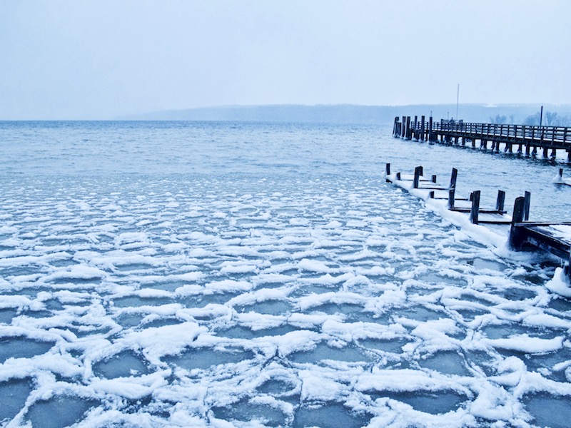
The blast of cold air from the artic has been already labeled: “The Beast From The East”. Scientists say that this happened due to “a freak warming around the North Pole”. They are somewhat alarmed about the retreat of Arctic ice during winter and the high temperatures. This weather pattern allowed the cold air on the other side to reach huge parts of Europe. There are now condition in Europe in some places which would normally apply to the polar region. It is not clear if global warming is causing this strange pattern or if other reasons are responsible.

However, very cold temperatures are not so unusual in February but what’s unusual is these sudden drops in temperature. They occurred also over Northern America in the last years and remind us sometimes on the “Day After Tommorrow” scenario in Roland Emmerich’s movie, even we can’t compare this to the “new ice age”.


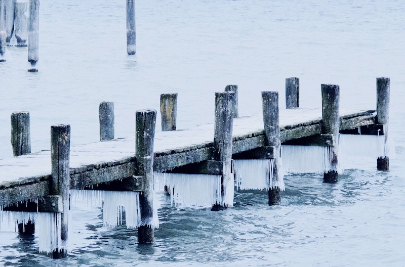
In this weather-conditions, there are many things to see. Even if there is not a frozen-waterfall nearby, wind, snow, and ice create interesting patterns or sculptures.

It is always promising to look what happens at a lake or a river. Here are some pictures which were taken at the Bavarian lake Ammersee.

Weather services announced warmer temperatures for the end of the week, but in these times we never know what exactly will happen. Thus, there is still time to do more pictures. Staying outside is normally not a big problem with the right clothes, however, some common problems need attendance: cameras and tripods get extreme cold and it’s painful if you have to take off your gloves. Batteries don’t last too long in the cold, but these problems could be handled with a little preparation, for example, do apertures settings and other settings before going outside if possible.

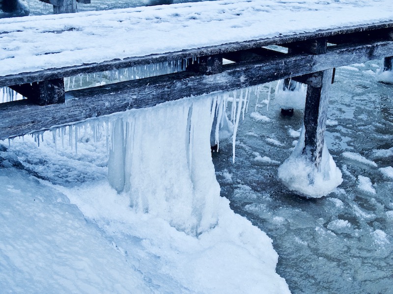
In the surrounding hills around lake Ammersee there are many open fields and spruces. The wind and the ice led also to bizarre formations.
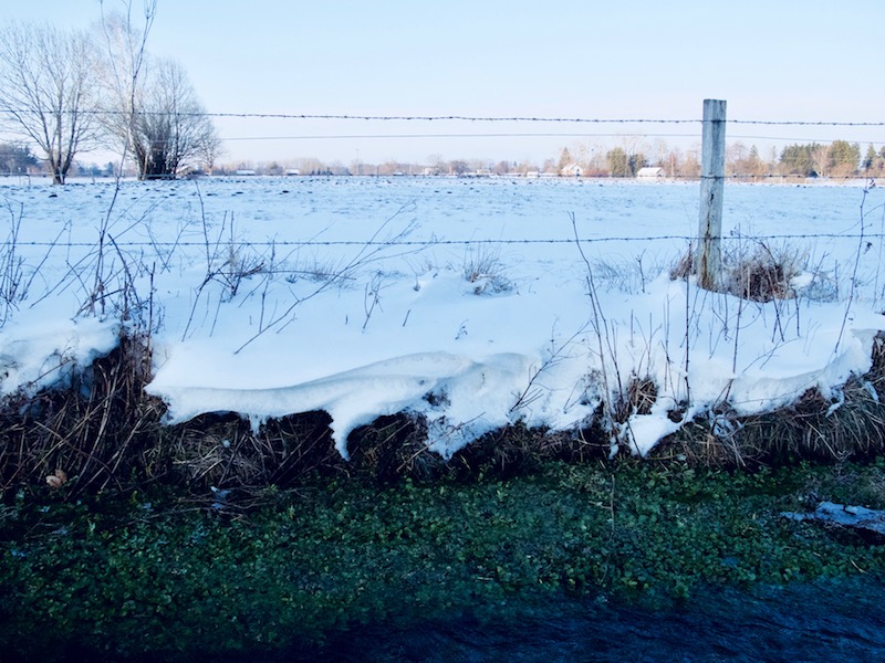
KelbyOne. Learn Photography from the World's Best Instructors.


Indian Summer And Blue October Sky, October 14, 2017

New temperature records were reached between October 11-17, 2017 in Eastern Germany. There was a long-lasting period of warm dry weather as in the same time Ireland and England got hit by devastating Hurricane Ophelia.

Even there are a few new extreme weather patterns the warm weather in autumn, however, is a normal phenomenon called “Indian Summer”. A term coined in Northern America it became synonymous with the time of colored trees and warm temperatures after the first cold days in autumn. In Middle Europe often a long-lasting high-pressure system is responsible for these periods of stable warm weather. However, due to the time of the year, it’s often accompanied by mist in the morning hours.

In the alpine region, the warm temperatures can be also created by the “Foehn“. There is also another term “Golden October” when the sun shines still bright and most of all we see a brilliant blue sky.

The sky is particularly impressing when going into the Alps where the sky is even bluer. The still strong sunlight bathes the mountains in a warm colored light.

This is a good time for photographers. The October sky is great for intense colors and even the days are already much shorter there are enough hours of sunshine.

The following pictures were taken at the south-side of the “Wetterstein-Mountains” in the Leutasch valley. The most famous mountain of the Wetterstein mountain is the “Zugspitze” near Garmisch. The Leutasch valley in Austria is less crowded and a great hiking area. One trail leads to the “Wettersteinhütte”, a cozy mountain cabin. Up there, there is a great panorama of mountains on all sides at a height of 1720 meters.

/a>Stock photography by Peter Engelmann at Alamy

Hikers love October because you have this spectacular distant view. The air is not so hot and humid as in summer and you can look very far. From the cabin (The “Wettersteinhütte”) the glaciers of the Tuxer Alpen (Tyrol) were visible that day. Morning hours are often the best time, thus it’s good to start the trip very early.


In the afternoon there are soon long shadows. Strong contrast is then the challenge for the photographer. Here HDR techniques could be useful. The best thing is to shoot in RAW-Mode to have a couple of options later.

An interesting phenomenon is the dynamic of the temperature during this season and type of October weather in the Alps: In the sunshine, it can be warm like in the summer. If you walk on a trail in bright sunshine it can be hot and you’ll start to sweat. However as soon as you descend into the shadows in the valley you feel an instant drop in temperature. And it doesn’t take long to get cold.

Sometimes pockets of warm air can still be felt or there is a sudden drop in temperature. Therefore hikers and photographers need to be equipped with clothes both for warm temperatures and colder temperatures. Nights can be really cold. Indian summer is a tricky thing – it feels like summer but it isn’t.

September 13, 2017, Storm Sebastian

Germany was hit on September 13, 2017 by a deadly windstorm. “Sebastian”. The storm did a lot of damage in Northern Germany and killed three people. Also Southern Germany was affected by the storm. In Upper Bavaria the alps could be seen very clearly. T

his was similar like the “Foehn-Effect” but not necessarily the same like the “Foehn-Effect”. The “Foehn” is a dry wind similar to the “Santa-Ana” wind, the “Foehn-Effect” on the East side of the Scottish Highlands or The “Chinook”. It occurs when moist air is rising on one side of the mountains and turns into warm downslope winds on the other side. Often it is the southern side of the alps where rain clouds are climbing.

Then it can become suddenly very warm in the valleys and the countryside adjacent to the mountains on the northern side. It could be also vice versa and then you have warm weather for example in the Tessin and a lot of rain on the Northern side of the alps.


The “Foehn-Effect” can be dramatic in itself. With temperatures climbing very fast there is a sudden danger of avalanches in the alps in the winter. Also, the “Foehn” is held responsible for health and mental problems. Sometimes when the traffic for example in Munich feels crazy, drivers doing weird things the “Foehn” is said to be the culprit.

In this situation, it was basically that the windstorm came from the Southwest. In Southern-Germany there wasn’t so much rain but there was no dust thus the Alps appeared closer as they are. The next day the weather calmed down but in some areas, there were still train delays due to Sebastian.

The windstorm was predicted but it is still a challenge for weather-services to predict the exact path of a storm. On a much minor scale, it was a bit like with “Irma” which took a slightly different path of destruction. It will be a task for the future to develop even more detailed systems for weather-warnings to prevent tragic incidents as it happened due to this windstorm.

The extreme weather events in 2017 raised again the question if the weather is becoming more extreme and yes, it seems true to a certain extent. It will be especially difficult also in the future to do precise nowcasts of storms like this one. Therefore it is important that people take precautions when severe weather events like “Sebastian” are announced. One important rule is to not go into the woods.

If possible driving should be reduced and people should be on alert when driving on rural roads with a lot of trees on both sides. Usually, windstorms in Europe do not destroy whole buildings so unlike the hurricanes people are safe when staying at home. “Sebastian” was the first windstorm of autumn 2017 and likely more storm systems will follow in Europe.

Storms happen between October and December but there is also often this “Foehn-Effect” in Bavaria or a longer lasting high-pressure system in Middle Europe. When this happens people speak of a “Golden October” due to the colors of the leaves. The “Foehn-Effect” is a chance for photographers in the alpine regions to take spectacular pictures but need sometimes a bit of experience due to the light conditions.

There is often a very bright light during daytime and in the evening the days quickly become shorter. Upper Bavaria, for example, offers many excellent viewpoints like the Hohen Peissenberg where there is an exceptional sight of the Alps.


Autumn Colors

Even October had been again too warm compared to average temperatures in middle Europe over many years before, the change of colors of leaves indicated that winter isn’t so far away. When green becomes yellow it’s an awesome sight. The wild Bode valley in the Harz Mountains sometimes called “the German grand canyon”, is always a great place for photography of nature, particularly in October. Vegetation looks in some spots more like in Norway or some remote alpine region rather than a forest in Northern Germany. In the lower regions of the Harz Mountains, the forest is dominated by beech trees and oak trees. The oaks are often smaller as in flat regions and exhibit bizarre forms on the top of the hills. At the “Hexentanzplatz” viewpoint above the valley and the village of Thale, you can see an endless forest with many shades of yellow and brown, and many visitors come here during the weekends.

The colors are further differentiated by the change between sunlight and clouds obscuring the sunlight. Even the so-called “Indian summer” or “golden October” is a very common motive it’s worth to take some time and watch the forest and landscape for hours.

Where we see a green sea of trees during summer there are now many details to be seen in the forest, and these details always change when clouds appear and create different settings of light. We might hope for these typical crisp and very clear blue sky days in autumn but for taking pictures a thin veil of clouds isn’t so bad because the light is softer, and you haven’t to handle as many sharp contrasts or very dark areas when taking pictures. Morning hours are often a good time before the mist has completely disappeared.

Enjoying nature or taking photographs in autumn is a lot about the right timing. It’s often only a few days in autumn where the veils of mist lift and the sun break through which offer unforgettable moments. In the mountains, one big storm or a lot of rain put the magic then quickly to an end. Unlike last year where a devastating storm hit Northern Germany in October weather was more friendly this year. Other areas in Europe weren’t so lucky when particularly in November Northern Italy and Southern France was suffering from flooding. The South side of the Alps got an incredible amount of rain. If it rains on the South side of the alps it gets warm in Southern Germany because of the “Föhn”-wind, a strong dry wind, which make the sky dark and blue and you can look very far. It’s also notorious for its effects on human health and behavior as giving you headaches. The phenomenon is a bit similar to the Santa Ana winds in California. The “Föhn” effect is also possible in lower mountain regions as the Harz mountains, however, doesn’t create such extraordinary clouds like in Southern Germany or Austria. The Harz mountains usually get more rain on the west and northern side where rain clouds from the Northern sea arrive. The Bode Valley is on the east side of the mountains. The Northern Germany region enjoyed moderate temperatures even in November and there weren’t really big disruptions from cold weather and snow so far. >